 I am a data scientist specializing in spatial analytics, GIS, urban informatics, and machine/deep learning.
With over 8 years of research experience, my work focuses on delivering actionable insights
that inform effective planning practices and help foster a more accommodating and safer transportation environment.
I am a data scientist specializing in spatial analytics, GIS, urban informatics, and machine/deep learning.
With over 8 years of research experience, my work focuses on delivering actionable insights
that inform effective planning practices and help foster a more accommodating and safer transportation environment.
My interests center around travel behavior — I study (1) how people move through urban environments, (2) the factors that encourage walking, biking, and public transit use, and (3) how travel behavior connects to public health and quality of life.
I also enjoy applying advanced visualization techniques and state-of-the-art analytical tools to urban studies. If you want to get a glimpse of what I do, check out the Research Highlights below.
Experience
-
Senior Data Analyst
Transportation Planning Department
Atlanta Regional Commission
Aug 2023 - present
-
Research Assistant
Center for Spatial Planning Analytics and Visualization
Georgia Institute of Technology
Aug 2019 - Dec 2023
-
Junior Researcher
Transportation System Research Center
Seoul Institute
Jul 2018 - Jul 2019
Education
-
PhD in City and Regional Planning
Georgia Institute of Technology
Aug 2019 - Dec 2023
-
MS in Urban Analytics
Georgia Institute of Technology
Aug 2021- Aug 2023
-
BS+MS in Urban Planning and Design
cum laude, University of Seoul
Mar 2010 - Aug 2017
Technical Skills
- Languages: Python | R | SQL | JavaScript | HTML & CSS
- Libraries & frameworks:
- Web dev: React.js | Node.js | jQuery
- Visualization: Mapbox.js | D3.js | kepler.gl | deck.gl
- Machine learning: PyTorch | TensorFlow | OpenCV | MMCV
- High performance computing: MVAPICH2
- GIS: ArcGIS | QGIS
- Other software: Tableau | Photoshop | Illustrator | AutoCAD
Interests
- Travel behavior | Active mobility | Smart growth | Transit equity
- Geospatial analytics | Visualization & mapping | GIS
- Data science | Machine/Deep Learning | Computer vision
- Network analysis | Urban modeling and simulation
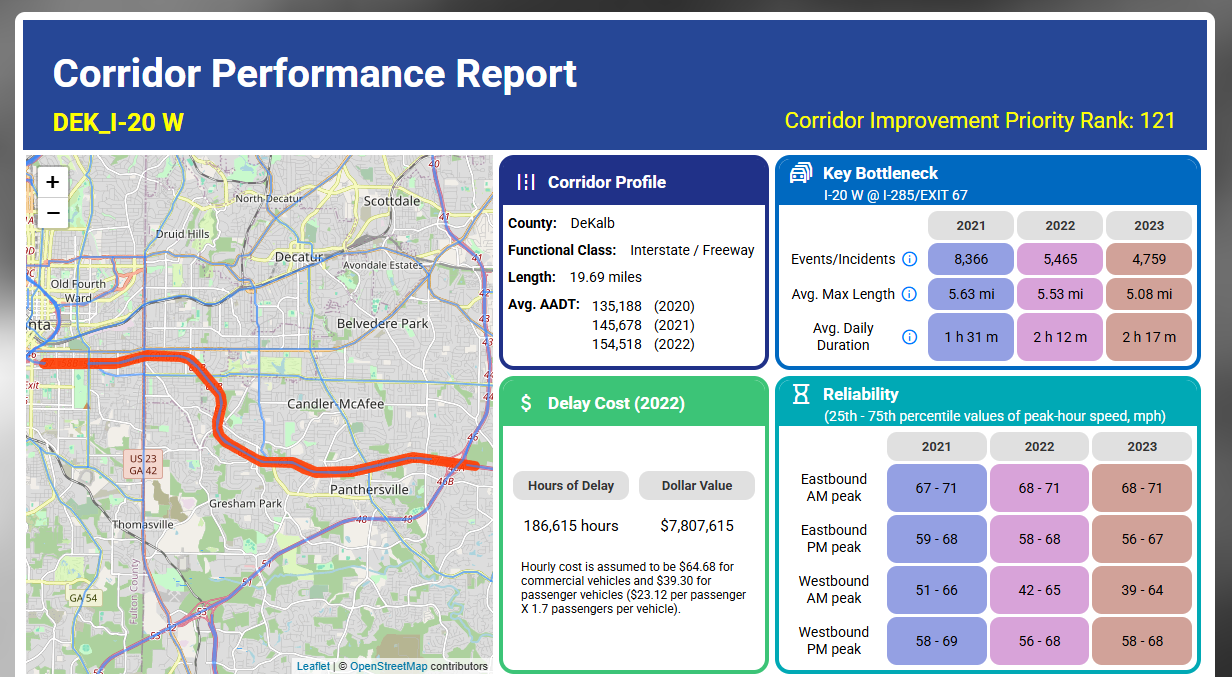
The Atlanta Regional Commission’s Corridor Performance Report offers an interactive,
data-driven view of 360 major roadway corridors across Metro Atlanta. It highlights
key metrics—including travel time, congestion, safety, reliability, and air quality—to
provide deeper insight into regional transportation performance.
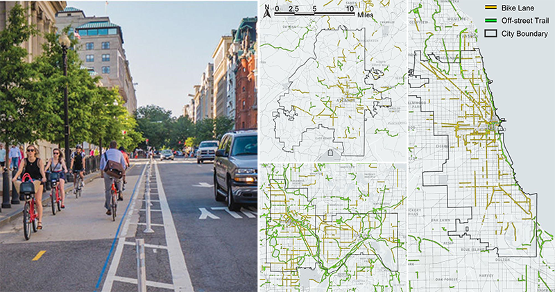
Making people drive less is the utmost goal in the major U.S. cities. By simulating bike routes of 120,000 trips and running a mode choice model, this study demonstrates that bike lanes not only support cyclists but also induce people to shift from driving to walking and public transit.
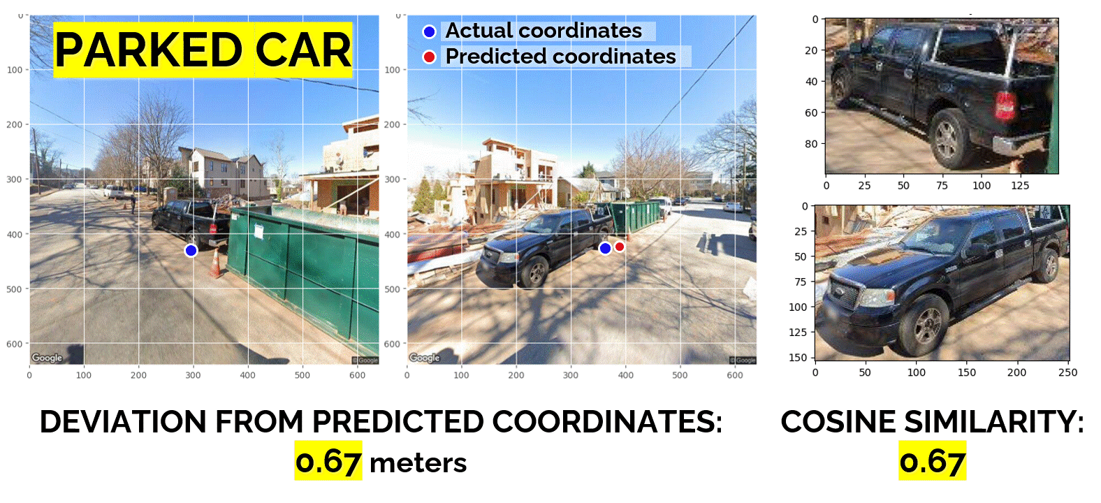
On-street parking is a necessary evil. This study introduces a method for detecting unregulated on-street parking from a sequence of street view images using image geometry and computer vision models such as segmentation models
(Xie et al., 2021;
Qiao et al., 2021),
a vanishing point detection model (Zhou et al., 2019),
and a vehicle re-identification model (He et al., 2020).
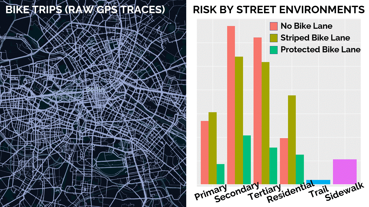
One of the challenges in biking safety research is the rarity of bike-involved accidents. A viable alternative is to study near-misses, which occur quite frequently.
Using Simra,
an app-based, crowdsourced dataset on bike routes and near-misses, this study examines the association between various street environments and the risk of near misses in Berlin, Germany.
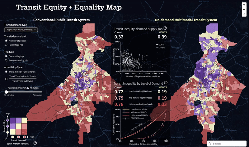
On-demand multimodal transit system in Atlanta is designed to connect people to rail/bus networks by serving first/last miles via on-demand shuttles. The novel transit system will surely improve accessibility, but will it make the transit service more "equitable" across the city?
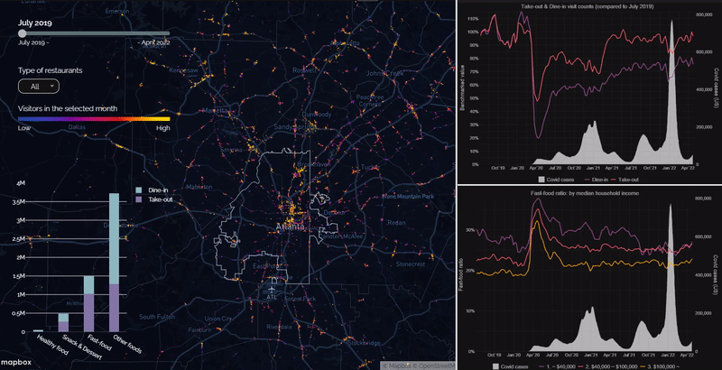
Eating behaviors are certainly one of the primary things that the pandemic has affected in negative ways. Using restaurant foot traffic data from SafeGraph, this study shows in what way our eating habits became unhealthier during the pandemic and how the changes differ by neighborhood characteristics.
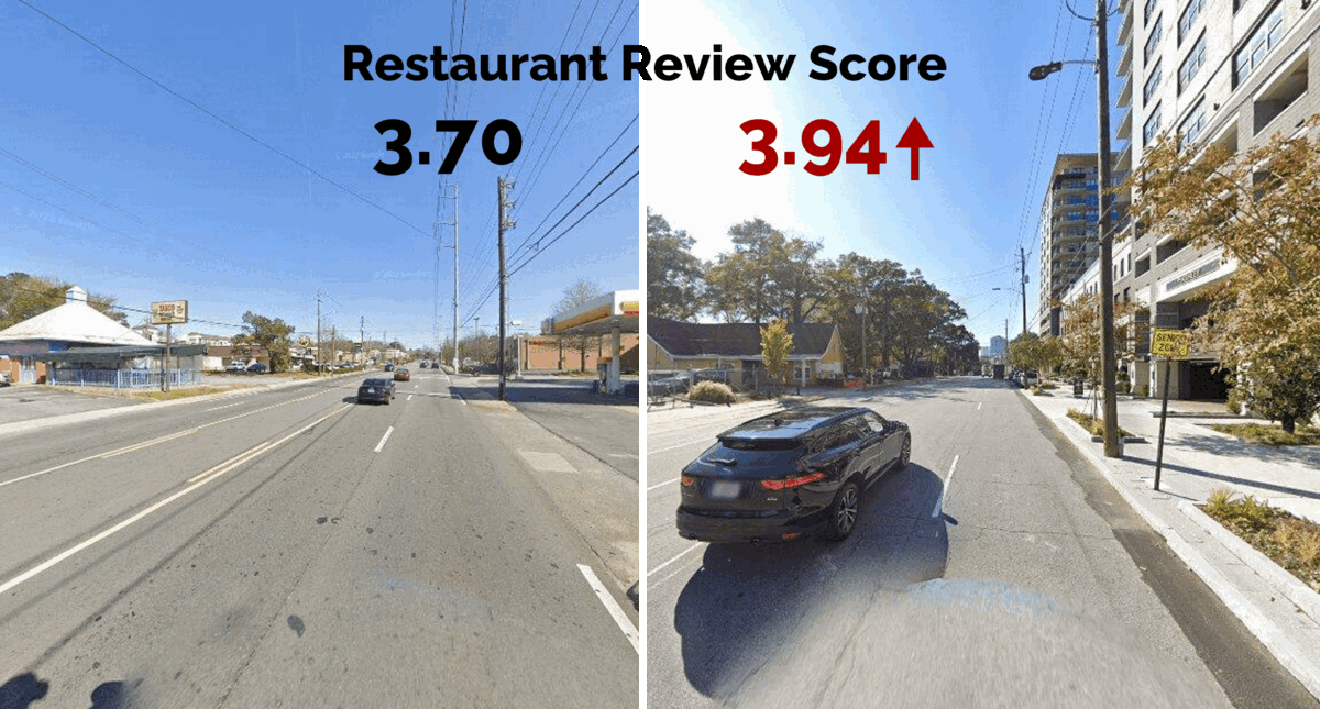
Walkable streetscapes are conducive to the perceived safety and aesthetics of the street frontage. This study extends the concept of servicescapes to the surrounding street environment. The analysis shows that the quality of streetscapes (measured through a computer vision based method by Koo et al. (2022)) has positive effects on customer satisfaction (derived from Yelp reviews).
Complete streets aim to ensure safe travel for all street users regardless of their age, ability, or mode of transportation. Due to the inevitable piecemeal nature of those projects, however, complete streets are not very complete from a network standpoint. This study investigates the design of a complete street network by using bike lane networks as connective threads.
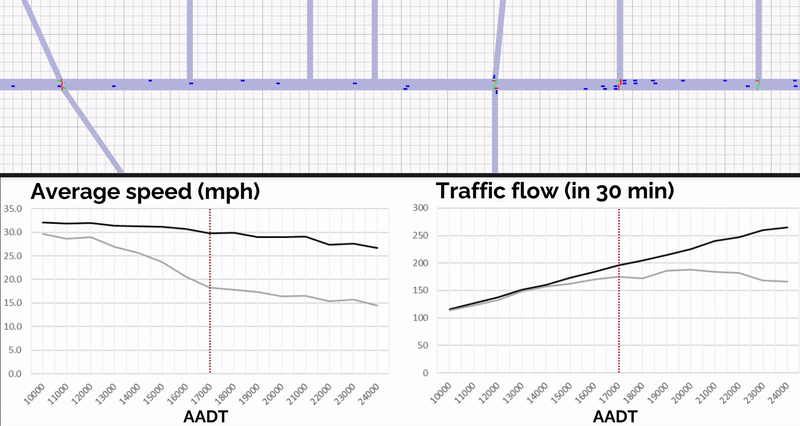
This study investigates the impact of a planned road diet on 10th Street NW on roadway performances.
A microscopic traffic simulation, building upon the work of
Treiber et al. (2000),
was conducted for two scenarios (i.e., before and after the road diet) under varying AADTs.
The findings suggest that the road diet will significantly reduce peak-hour speed,
and traffic flow is projected to moderately decrease by 11% due to the reduced capacity.
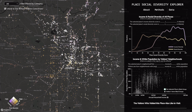
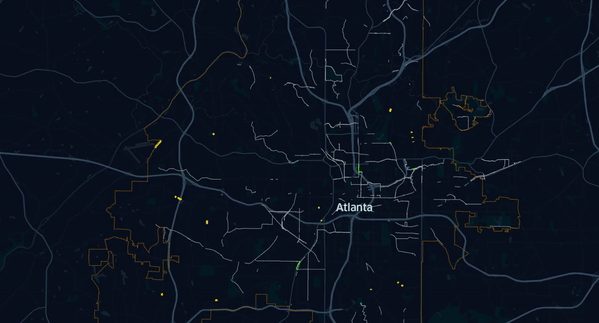
Explore the social diversity among visitors at third places in the City of Atlanta. What types of places let you intermingle with people with diverse backgrounds? The visualization was created by Uijeong Hwang and Xiaofan Liang based on data shared by Seolha Lee.
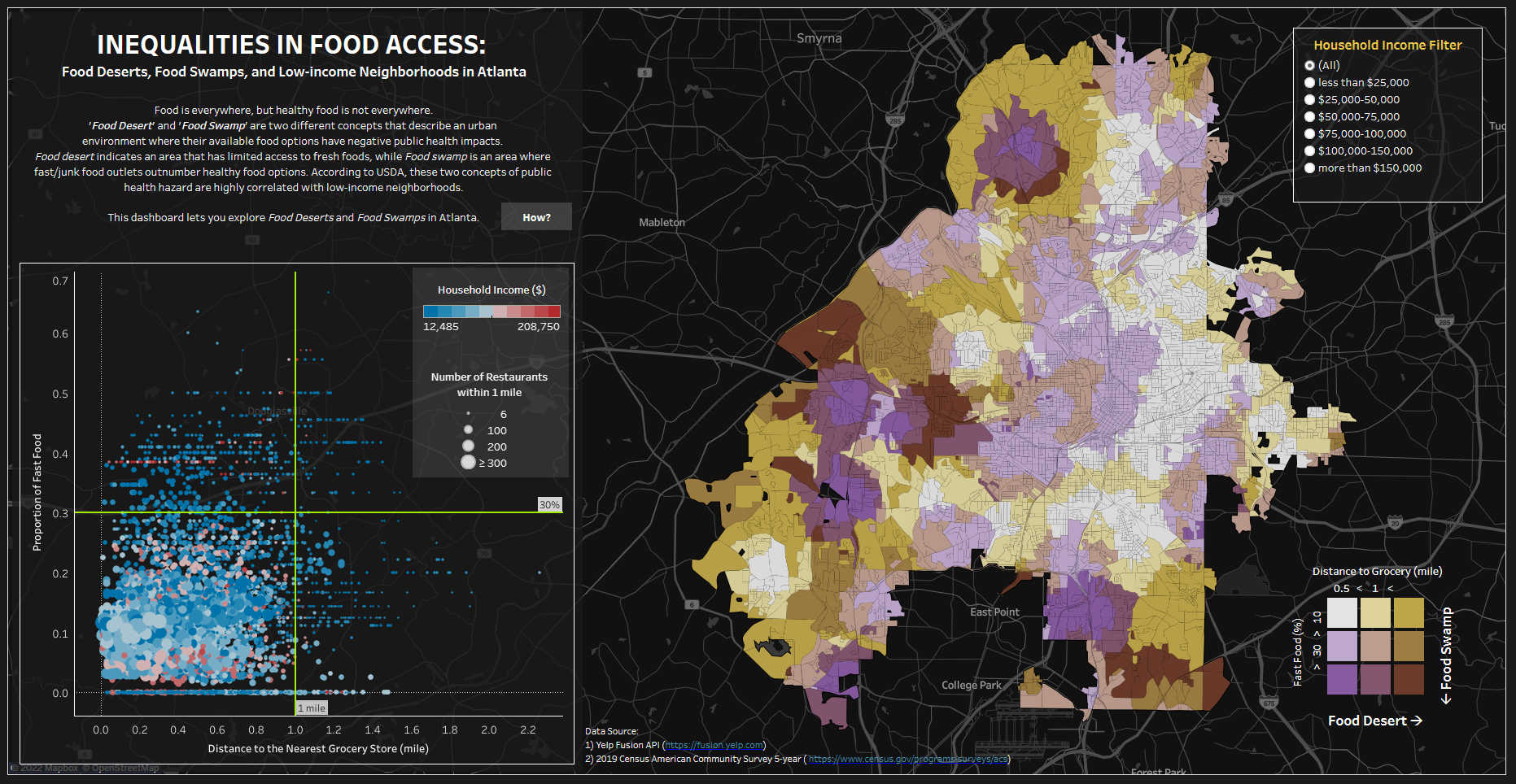
Food is everywhere, but healthy food is not everywhere. Many neighborhoods in U.S. cities are surrounded by fast/junk food outlets and have limited access to fresh foods. This dashboard demonstrates which neighborhoods in the City of Atlanta are at risk of being public health hazards and how it is correlated with the neighborhoods' income.